Español
 ") English (UK)
English (UK) Trip Planning Options
- Plan your trip using Google Maps
- Use the METRO System Map and zoom into as much route detail as needed (play with Map, Satellite Views!)
- Pick up a free quarterly Headways - Bus Riders Guide to carry with you, and plan your trip using the Maps, Route Locator, and instructions provided within
- Be sure to check our Service Calendar and News Bulletins to make sure the trip that you intend to ride is operating that day
- Need route and schedule information? Call Customer Service during business hours
Stay Informed, Sign Up For Updates
- Click here to subscribe to our free email notification of agency information
- Choose from a wide range of service alerts and agency-related information as it becomes available
- Update your preferences at any time
- Visit our News Bulletins page to stay informed with:
- Quarterly Service Updates, Service Alerts, Announcements, and Public Hearings
- Related bulletins are also shown in context with each individual route
Helpful Tips for Reading a Metro Headways - Bus Riders Guide
-
Schedules
- Every METRO routeconsists of a timetable combined with a map, which is the schedule
- Each bus stop displays the schedules of each route served by that stop
- The Headways -Bus Riders Guide contains all schedules. These schedules are also avalable on wall posters at Transit Centers
- The website also offers printable publications for each route, wherever you see this icon

-
Route Titles
- The heading of a timetable and its map consists of a route number with a route title
- This route number and title is similar to the destination sign of the bus
- A title that includes School-Term Only indicates that the entire route runs only when related schools are in session
-
Service Frequency
- A Service Heading labeled Daily means that the same service schedule runs seven-days-a-week
- The Weekday Service Heading is labeled Monday - Friday (Mo-Fr)
- The Weekend Service Heading is labeled Saturday - Sunday (Sa-Su)
- Each route may operate either or both weekday service and weekend service
- A route that operates both may either show a combined timetable or show separate weekday and weekend tables when they are too large to combine
- Holiday Service:
- Service frequencies vary on holidays, consult theHoliday Service Calendar
- Night Owl
- Weekday Service is labeled Sunday - Thursday (Su-Th)
- Weekend Service is labeled Friday - Saturday (Fr-Sa)
-
Timetables
- Timetables consist of a Route Title and a table in which Timepoint locations are the column headings, followed by rows of trips
- Timepoint locations are major bus stops described in the column header and symbolized with capital letters (A, B, C...) These letters correspond to locations on the Route Map and System Map
- Each row across the timetable follows that particular trip,showing the departure timepoint and location, and the arrival timepoint and location of the route's destination.
- In between timepoints, there are usually more stops, which are shown on the maps, but are NOT shown in the timetable
- A dash ( -- ) in place of an actual timepoint means that timepoint location is not served on that trip
- Footnotes are sometimes shown under a timetable to convey additional information regarding that route or certain trips or timepoints on that route
- To estimate when your bus will arrive at your location, reference the closest major timepoint (A,B,C...) described in the column header
- Google Transit trip plans will always calculate and display a stop's passing time for you
- Timetables consist of a Route Title and a table in which Timepoint locations are the column headings, followed by rows of trips
-
School Term (ST) Trips vs School Term Only Routes
- Some routes designated School Term Only in the Route Title , run when related schools are insession. The School Term Calendar always includes the route schedule when applicable
- Some routes have special trips marked with School Term (ST) in the timetable, indicating that particular trip only runs when related schools are in session
-
Stops
- All bus stops are indicated by either a dot or a timepoint letter on the maps (see below)
- Within certain technical limitations, all timepoint locations will be announced by the automated Call Stop Announcement System
-
Online System Map
- The interactive Google Map on our website is called our System Map
- It allows you to zoom in/out and see the context of the route including all stops and timepoints
- Timepoints are shown as dark blue "pushpins" with bold white capital letters (A,B,C...)
- Stops are shown as red dots with a bold yellow border and are clickable for more detail
- To quickly zoom in to see a stop, click on it an choose the link "Zoom to location"
- Switch from Map, Satellite, and Terrain views to actually see where stops are located in relation to known landmarks, buildings, steets, roads and elevation
- Zooming in and out and panning can be done by using the map controls in the upper left
- a double click will also zoom in one level, but this won't work while clicking on the route line, or the stops/timepoints
- dragging the mouse (holding the mouse btton down while moving it over the map) will pan around the map while staying at the same zoom level
- Use the Google traffic layercheckbox to show or hide a live traffiic overlay provided by Google
- green lines mean traffic is flowing well
- slower traffic ranges from yellow to red
- road incident symbols also appear and are clickable for details
-
Route Maps
- Route Maps are designed as the official "print version" map included with each route schedule and contain more detail than the System Map
- A legend explains the symbols used
- A solid dark-blue Route line shows the path of all trips
- A dashed or styled dark blue Route line shows the path of selected trips which deviate from most trips and are explained in the text boxes in the map
- White triangular directional arrowsindicate the path of travel along the route
- a double arrow indicates that the route travels in both directions along that segment of the route
- Timepoints are shown as dark blue "pushpins" with bold white capital letters (A, B, C...)
- Stops are shown as pale yellow dots with a thin black border

Santa Cruz METRO Operates Four Transit Centers in Santa Cruz County.
Santa Cruz Metro Center (Pacific Station) Relocating Feb. 12th, 2024 to temporary River Front Transit Center.
River Front Temporary Transit Center
Pacific Station Relocation
The METRO Pacific Station complex in the city of Santa Cruz is slated for demolition and redevelopment during the period of February 2024 through February 2026. Current METRO operations at Pacific Station includes 10 active bus bays, 14 layover bus bays, a site-specific circulation system, and facilities for public/customer service interaction, operators, and security staff. METRO operates county-wide fixed-route and Highway 17 commuter service from its Santa Cruz Pacific Station complex with connections to Santa Clara County and Monterey Salinas Transit at METRO’s Watsonville Transit Center. METRO operates a fleet of 107 buses on at least 20 fixed routes and 32 paratransit vehicles.
On Thursday, February 8th METRO’s Customer Service booth and ticket sales at Pacific Station will close to the public, and the lobby and public restroom will remain open until end of day Sunday, Feb. 11th. On Monday, Feb. 12th, METRO will move transit operations to its temporary River-Front Transit Center utilizing curbside space on Soquel Ave., Front St, River St. and River St. South to create three new bus stops (Areas 1, 2, 3) and create multiple bus layover spaces. METRO’s Customer Service booth and ticket sales will also open on Feb. 12th to the new Customer Experience Center located at 603 Front St. in Santa Cruz.
To help ease this transition for riders and acquaint them with the temporary transit center, METRO will offer free fares throughout its bus system from Feb. 8-25. Additionally, over a dozen METRO operator trainees will be available onsite Pacific Station and River- Front Transit Center during the transition period to assist riders with finding their routes and answering questions.
River Front Temporary Transit Center Plans
Per the terms of the 2020 Memorandum of Understanding between the City of Santa Cruz (City) and METRO, the City is coordinating the development of a METRO Downtown Transit Center Interim Operations Plan (Plan). The Plan will design temporary traffic circulation patterns, determine associated traffic and sidewalk revisions, and identify locations for ancillary facilities to support METRO’s operations during the redevelopment of Pacific Station. Key elements include establishing a clockwise traffic flow around the area bounded by Soquel Ave., Front St., River St. and River St. South, the removal of the traffic island at the River St. South/Front St. intersection to facilitate METRO bus movements, general traffic restriping, and conversion of River St. South to one-way southbound.
The METRO Interim Downtown Transit Center Operations plan will utilize curbside space on Soquel Ave., Front St, River St. and River St. South to create three new bus stops and create multiple bus layover spaces. On Front Street and River St., the plan will create a shared bus/bike lane adjacent to the curb to facilitate bus movements, bus layover, bus station service, and bicycle movements. METRO plans to board and deboard passengers at three bus stops (Areas 1, 2, 3), located at the River St. South/Soquel Ave. (Area 1) intersection, at the existing stop on Soquel Ave. between River St. South & Front St (Area 2), and at the existing Front St. stop alongside CVS Pharmacy (Area 3). Layover spaces will be generally used between 5am and midnight, when most of the bus routes are out of service.
To install the shared bus/bike lane, there will need to be a reduction of on-street parking. Existing loading curbside spaces will be maintained. A description of these parking changes is detailed below.
City of Santa Cruz - Metro Interim Downtown Transit Center Plan.
Area 1, 2, 3 Route Details
Area 1: Located at the River St. South/Soquel Ave. intersection
Routes Served: 18, 19, 20, 40, 41, 42
Area 2: At the existing stop on Soquel Ave. between River St. South & Front St
Routes Served: 17, 35
Area 3: At the existing Front St. stop alongside CVS Pharmacy
Routes Served: 1, 2, 3, 4, 90X
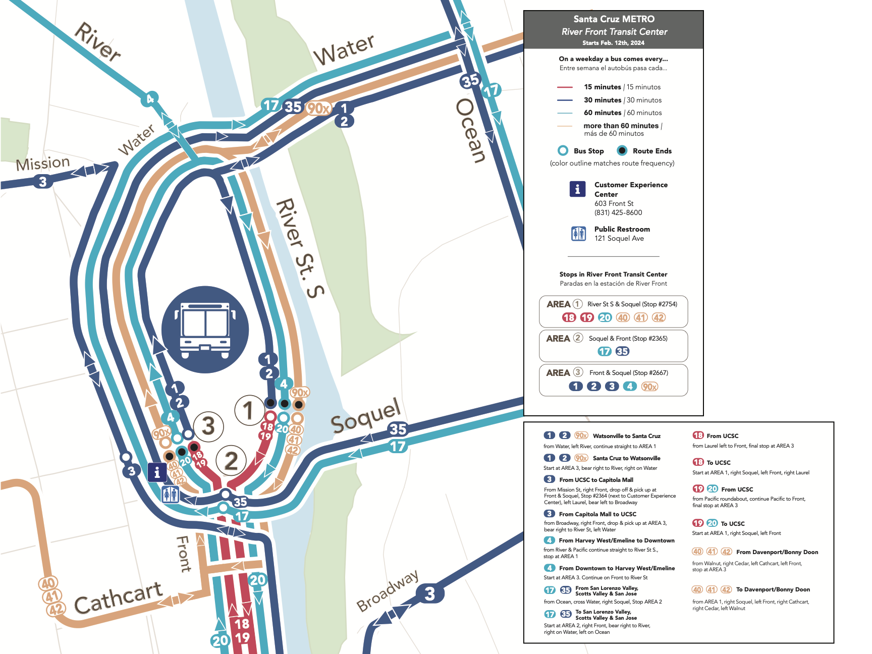
Click here to view a larger River Front Transit Center Map
Customer Service
Additionally, METRO’s Customer Service Department will also be relocated from Pacific Station to 603 Front St., across from CVS. METRO’s Customer Experience Center will be open to assist customers in-person Monday – Friday, 8:00AM – 5:00PM or by phone at (831) 425-8600.
Public Restrooms
METRO riders will have access to a public restroom near Soquel/Front Parking Garage at 601 Front St. facing Soquel Ave., located next to Oswald’s Restaurant (121 Soquel Ave.) and across the street from New Leaf.
Walking Directions from METRO’s Customer Experience Center: Head South on Front St. Towards Soquel Ave., turn right on Soquel Ave., walk past Oswald’s Restaurant, public restrooms will be located on your right
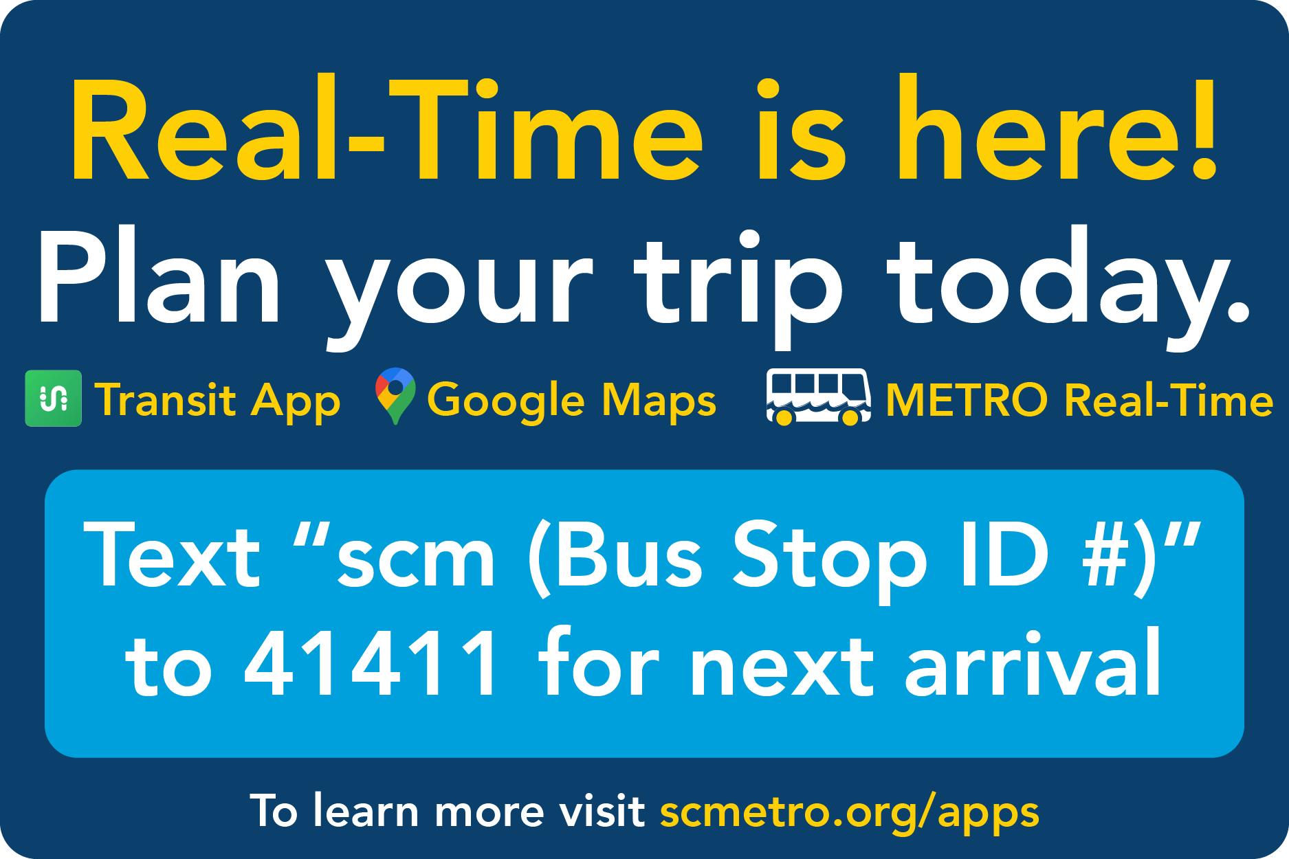
Real-Time Bus Tracking
METRO is now providing a real-time bus arrival feed utilizing GTFS-RT, the transit industry standard, that enables riders to access real-time information on routes and bus locations in the most popular travel apps and websites. Real-time arrival information enables riders to know exactly when the bus will arrive, be aware of disruptions to service, such as traffic incidents, and know how full the bus is before it arrives. Travel with greater ease by taking advantage of real-time information that will help you make better trip decisions, using any platform you prefer:
- Transit App and other popular smartphone apps
- Google Maps and Apple Maps Trip Planners
- METRO Real-Time website
- SMS Text message “SCM XXXX” to 41411 (where XXXX is either a numeric stop ID, or transit center lane such as “rfc1” or “wtc2”) for predicted arrivals within 30 minutes
For more information visit scmetro.org/apps.
 Cavallaro Transit Center, Scotts Valley
- This Transit Center is not staffed.
- Address: 246 Kings Village Road, Scotts Valley
- Routes: Amtrak/Highway 17 Express, 35
- View Today's Departures with Schedule By Stop
Capitola Mall Transit Center
- This Transit Center is not staffed.
- Address: 1855 41st. Avenue, Capitola
- View Today's Departures with Schedule By Stop
Watsonville Transit Center
- Address: 475 Rodriguez Street, Watsonville
- Services:
- Customer Service Kiosk available 7 days a week, 8AM – 5PM
- View Today's Departures with Schedule By Stop
-
Transit Associations:
|
|
|
|

Here are some helpful links to agencies in the San Francisco Bay Area.
Please feel free to let us know of any other sites you would find helpful here.
-
Transit Systems
-
Transit Related Services
- Association of Monterey Bay Area Governments (AMBAG)
- Bay Area Transit - Information on All Systems
- Caltrans
- California Department of Motor Vehicles (DMV)
- California Public Utilities Commission (PUC)
- Stanford University Transportation Programs
- Santa Cruz Area TMA (Ecology Action)
- Santa Cruz County Regional Transportation Commission (SCCRTC)
- Santa Cruz Road Information - Caltrans District 05
- Santa Cruz County Conference & Visitors Council
- UCSC Transportation and Parking (TAPS)
- Association of Monterey Bay Area Governments (AMBAG)
Directions Northbound to Mineta San Jose International Airport (SJC) from Santa Cruz
There are multiple ways to reach SJC airport via public transportation. The most efficient option varies depending on whether it is a weekday or weekend, and on the time of your arrival into San Jose. In some cases the preferred option is VTA light rail to Metro/Airport Station, connecting to the VTA #60 Milpitas BART to Winchester Station via SJC Airport (Destination “Winchester Station”). At other times, the faster option may be VTA bus #22 or #522 to Santa Clara Caltrain Station, connecting to VTA #60 Milpitas BART to Winchester Station via SJC Airport (Destination “Milpitas BART”). Google Trip Planner or Transit App are useful in determining the most efficient option for a specific time.
Here are instructions for travel between San Jose Diridon Station or Downtown San Jose and SJC Airport using VTA Light Rail:
Weekdays/Weekends
- Take Amtrak Highway 17 Express Northbound from Santa Cruz to the Diridon Station (allow approximately 60-80 minutes travel time, depending on traffic conditions)
- Walk through the Diridon Station and through the tunnel and turn left to the Light Rail station. Take VTA Light Rail - Green Line (formerly the Winchester – Mountain View line) northbound (destination sign reads “Old Ironsides) to the Metro/Airport Station. Stop announcements will be made on the train (allow 15 minutes travel time)
- Cross 1st Street to the glass gazebo bus stop
- Wait for the VTA #60 Milpitas BART - Winchester Station via SJC Airport (the destination sign will read Winchester Transit Center)
- This will take you to the Mineta San Jose International Airport (SJC) and makes stops at Terminals A and B. The Line 60 runs approximately every 15 minutes during the day on weekdays; every 20 – 30 minutes in the evening and on weekends.
Unlike the former #10 Airport Shuttle (now discontinued), regular fare is required for this route. If you use a Clipper card for both light rail and #60, there is a free transfer.
Directions Southbound to Santa Cruz From Mineta San Jose International Airport (SJC)
Weekdays/Weekends
- From any Terminal take the VTA #60 Milpitas BART - Winchester Station via SJC Airport (the destination sign will read Milpitas BART).
- This bus will take you to the 1st & Metro stop.
- VTA #60 is free to ride from the airport terminal and runs approximately every 15 minutes (allow approximately 10 minutes travel time)
- Cross over to the Southbound Light Rail track from the bus stop
- Take the VTA Light Rail - Green Line (formerly the Winchester – Mountain View line) ONLY! (the destination sign will read Winchester Station)
- This train will take you to San Jose Diridon Station (allow approximately 20 minutes travel time)
- Walk through the tunnel and the station building to the bus bays and take the Amtrak Highway 17 Express Southbound from San Jose to Santa Cruz Metro Center (allow approximately 60 minutes travel time)